It’s always about the light – the Better Beamer

Today, I was roaming around looking for something to take pictures of.  I ran across a Red-bellied Woodpecker on a snag not far from downtown.  The angle was a little low but, that’s often the case with woodpeckers so, I started shooting.

Unfortunately, the sun was at the wrong angle for where the bird was working.  I was getting it going in and out of shadow and, in Florida, that’s a major difference.  I could shoot and figure on postprocessing to take care of the awkward shadows but, I’m much happier when I can get the light right in the shot.

This is one that took a little bit of post to lighten up  the head but isn’t too bad.

But, it still wasn’t right.  I decided to use my SB-800 flash to provide a little fill.  In fact, it was used in the picture above but I still needed to postprocess to get it halfway decent.  Then, I remembered that I had my Better Beamer in the back of the car.  The Better Beamer is a contraption that holds a Fresnel Lens in front of the flash and focusses it at a longer distance.  When I got back from attaching it, the bird had moved but I took two pictures in the new position.  The one on the left is the flash alone and the one on the right with the Better Beamer.
    

Wow, what a difference.  The bird then moved to the shady side of the tree and the Better Beamer made for a nice even light.  To be honest, it’s perhaps a little too even and looks somewhat artificial.

Still, it is much better than the shots I made afterward without the attachment.

Posted in Bird, Camera Gear | Tagged , , , | Leave a comment

Babcock-Webb WMA – Misty morning at Marl Pond 3

Most of my posts on Babcock-Webb are intended to provide a bit of a guided tour around the area.  I usually shoot them during the day when the light is good for descriptive photos to accompany the text.  But, the real beauty of the place shows in the early morning and evening when the wildlife is active and the light is changing by the second.  

This was taken on the morning I decided I needed to cover Oilwell Grade south of Tucker.  I went over early hoping to catch the mist on Webb Lake.  Unfortunately, my timing was slightly off and the sun was higher than I wanted.  There was still mist in the trees but, the lake was clear.  You can see in this picture of Marl Pond 1, at the entrance, that the mist was no longer holding on the open water.


When I got to Marl Pond 3 there was still a slight mist over the water and the sun was high enough that the shadows of the trees were being cast through the mist.  I still had the mist in the trees as a background making for a pleasing sunrise picture.

Posted in Park - Babcock Webb WMA, Scenic | Tagged | 1 Comment

Babcock-Webb WMA – Seaboard Grade – North of Tram Grade

This is a rustic road with some patches of sugar sand but, none make it impassable with a high clearance vehicle  as far as Powerline Grade.  It can be driven by car for some distance.  This is the entrance at the intersection with Tram Grade.

The ground here is slightly higher than the other sections of Seaboard grade and there are a lot more mature trees and the forestation is somewhat more dense than the typical pine flatwoods.  There is a sump there on the right hand side that often has a gator or two hanging around.  In fact, I noticed one lying at the eastern edge of the sump and was delighted to find that I had found an Alligator nest with Mama watching over her babies.  You need to be very careful and move slowly and unthreateningly when you come across this situation.  Unlike other reptiles, female alligators protect their young from threats.  Don’t be a threat.  Florida is NOT a petting zoo.

Further down the road you will reach the intersection with Powerline Grade.  To the east, Powerline ends, a couple of hundred yards away, at a gate which is locked except in hunting season.  To the west, however, it continues on until you reach another locked gate several miles away near the Punta Gorda Utilities facility on Bermont Road. (Highway 74). 

 Because Powerline is kept free of undergrowth it’s a long hot ride.  The other roads are generally preferable since you are in the shade most of the time but you can see into the woods from Powerline.  Beyond Powerline, the road gets a little rougher but is still passable for about a mile until you hit another locked gate at the intersection with Numbered Road 1.

Unfortunately, Numbered Road 1 is on the far side of the fence.  There is a non-vehicular gate though so it is possible for walkers, cyclists and equestrians to continue onward on Seaboard or explore NR 1.  Due to the lack of vehicular traffic, the road beyond the fence is actually in excellent condition.  If you click on the left picture here, you will see a white spot down the road a ways.  That’s a rider on a brown horse.


Both of these roads continue to the end of the property.  Road 1 ends at Route 31 with another locked gate.  This area is used for cattle ranching and you will find a water trough immediately inside the pedestrian gate.  There are often cattle in the area but are not threatening.  The ones I have run across seem curious.  This is a very pleasant area to wander and watch the woodland birds.


Posted in Park, Park - Babcock Webb WMA | Tagged | Leave a comment

Babcock-Webb WMA – Oilwell Grade south of Tuckers Grade

This is a somewhat different road for the WMA.  It’s hardshell and passable for most vehicles.  While most of the recreation area is pine flatwoods, this section is more like dry prairie.   There have obviously been some fairly recent controlled burns along this road.It runs in a generally straight line until it ends at a shelter on the east side of Webb Lake.  It looks like a great place to start a kayak or canoe paddle.

the road doesn’t actually end here but it is no longer hardshell and there are signs saying not to take vehicles beyond the point.  Those sand roads though are great for walking along the banks of this marshy arm of the lake.  When doing so though, be careful.  There is no way to cross the lake.  It is 7 miles end to end with a lot of small coves and arms so walking all the way around most likely exceeds 25 miles.  Whichever way you start out, you will be walking back the same way.  There is parking for a few cars and vans near the shelter.

This would be a great place to start a pinewood cycling day.  The road to the west, while sand, is firm and passable.  If not forbidden it would be a fairly easy ride with a high clearance vehicle.  Both sides are nice walks too.  The western path goes by a pretty narrow part of the lake.  You will often see deer in the area on both sides of the lake.

If you take the eastern branch you walk around the cove with your car nearly always in sight from the roadway.  In fact, you will get to the other side and actually start getting closer to your car (except for the lake of course).  The undergrowth here is grassy so taking a walk off the road into the pinewoods.  If you look at the picture below you will see a bed of Alligator Flag in the distance just before the trees get heavier.


Alligator Flag is a clear indication of an area that is wetland.  This plant dies off if the lower stalks and roots are not immersed.  I didn’t go over there today but, once the dragonflys start emerging in good numbers I will definitely be checking it out.

I’ll remind you again though.  Florida is NOT a petting zoo.  This habitat is prime for snakes and the Alligator Flag got it’s name for a reason.

This is one of the little places in the Babcock-Webb WMA that most folks never see.  I hope you enjoy it if you ever get out there.

Posted in Park, Park - Babcock Webb WMA | Tagged , | Leave a comment

Prairie Creek Preserve

Prairie Creek Preserve is a relatively new preserve and does not have facilities of any kind.  It has been left in as natural a state as possible since Charlotte County procured the land.  It consists of about 1600 acres with Prairie Creek running through the middle.  The preserve is located outside of Punta Gorda off Route 17.  It is easily found by passing both ends of Washington Loop Road and immediately looking for the Brown signs for the facility.  The first warns of the entrance being 1500 feet ahead and the second is at the entrance road.

The entrance to the preserve is actually about 3.75 miles down this road but, don’t be in too much of a hurry.  There is a small drainage canal on the left side that becomes wide occasionally.  Today (2/16/11) I found this Little Blue Heron (Egretta caerulea) and Greater Yellowlegs (Tringa melanoleuca) wading around.


Most of the road though is working farmland or grazing land.  Eventually, you get to the main entrance to the Preserve.  This is just a gate and cattle grid but there is a seasonal wetland there that is excellent for dragon and damselflies.  Most of the land on the left side is dry prairie with a few pines scattered in it.  It’s been cool lately but this section is also great for wildflowers like this tiny little snapdragon.  It’s bloom is less than 1/4 inch across.

About 3/4 if a mile further and you find another gate where you will need to turn left and proceed about another 1/2 mile to the parking area.  The road is wide enough to pull off, or at least well over, after you reach the  first Preserve gate so don’t feel you need to miss anything and walk back from the parking.  That area is really just a wide area at the end of the road where there are the remains of a cattle loading area.  There are a couple of ranch enclosures there and this overgrown loading ramp.

This is the end of the hardshell road and the beginning of Pedistrian and equestrian paths.  It is a short walk to the creek through  the  pedestrian gate on the wide road leading toward the oak trees.  The first trees and habitat you will see is Saw Palmetto and pine.  If you plan on walking through here better wear heavy trousers and boots and stay alert for snakes and pigs.

This is very heavy undergrowth and I saw several new firebreaks which might indicate that a controlled burn will be coming soon.  If you take the wide road though you will eventually come to an open area which is primarily Oak and light undergrowth.  There are plenty of signs of feral pigs here.  They aren’t usually a problem but Mama can get upset if you get too close to her piglets.  What you will see is torn up ground where the pigs had been digging up acorns from the oaks.

This open space is on the creek which hidden by the underbrush until you walk to the bank.  The landmark here is an old Oak snag hanging over the water.  It is obviously used as a swimming hole by some because there is a swinging rope hanging from a branch.

There is a path that follows along the river sometimes close and sometimes a little further away  but all along the way you will be in the shade of very old Oaks festooned with Spanish Moss.  Here are a few shots from the path.  Just click on them for larger versions.


Posted in Park | Tagged | 1 Comment

Feeling crabby?

I made a couple of shots of fiddler crabs recently and decided I wanted to identify them.  It turned out to be a bit harder than I thought.  Turns out there are nearly 100 different species of Fiddlers and I could only find one picture of this one.

Unfortunately it appeared on a list of unidentified species.

UPDATE: Thanks to the fiddlercrab.info site it was identified as Uca Pugilator but they are not normally so brightly colored.

This one I do know though.  It isn’t a fiddler it’s a Mangrove Tree Crab.

Of course, we also have the Blue Crab but this Yellow-crowned Night Heron beat me to it.  From the claw on the ground, it’s a female.

Posted in Other Animals | Tagged | 2 Comments

Babcock-Webb WMA – Seaboard Grade – South of Tuckers Grade

This road should only be attempted with high ground clearance vehicles. There was a ford not far from the intersection which has been graded but the road is still narrow and turn arounds are limited.  It starts at an old cattle grid at the intersection with Tucker Grade and dead ends at about Road 10 where the grade just stops.  High ground clearance vehicles should have no problem with this road.  There are two other drainage crossing which are in good condition and have small ponds associated with them which are good places for Herons and Egrets.  Shortly after the start of this section, there is an interesting site.  It’s a grave for a hunting dog.  This appeared a couple of years ago and while the handprinted notes which showed the love for the dog are gone and the nametag on the  cross has faded away, the area somehow remains clear of debris.

The road is sandy but firm now that they have removed the first fording.  This is an old grade with mature trees reinforcing the edges.  Beyond those trees you will find pine flatwoods and marshland.  It is possible to drive a standard car here but in some places the ruts are deep enough to cause bottoming and the saw palmetto between the trees can scratch if you ride the ridges.  The drainage canal is on the left side of the road heading away from Tucker Grade.  It’s a good place to look for Gators when full.

Ultimately, the grade just ends.  The last time I was there there were a lot of commercial beehives at the end of the grade.  It is possible to go further in a high clearance fourwheel drive vehicle but the least amount of rain can turn the ground very soft.

Posted in Park, Park - Babcock Webb WMA | Tagged | 1 Comment

Babcock Webb – Numbered Road 10

I had seen the posts indicating numbered road 10 before but it had always looked like a rough path, generally overgrown which was not suitable for most cars.  On my trip down Tucker Grade to Route 31 though I discovered that one part had been gravelled between Tucker Grade and Powerline Grade.  This looks like it had been done by Florida Power and Light to provide a midpoint access to Powerline Grade.  Whatever the reason, it is now a passable road although only accessible by hikers or during hunting season when Tucker Grade is open.

The access point is easy to see on Tucker Grade.  The turn has a pretty wide grade and is an excellent turnaround if you aren’t going to go the whole way out to Snag Lake.

The road proceeds through the typical pine flatwoods of the area.  Interestingly, there are pines with the painted bands of a Red Cockaded Woodpecker nesting sites here.

Along the way, you can see the road signposts.

but, when you hit powerline, it’s the end of the road.  While Road 10 actually continues to intersect with Seaboard Grade it is not passable except by offroad capable vehicles.

Powerline is an easy drive but, is usually locked at various points.  I did not travel it but, suspect that the next access points would be Tucker Grade near the access to the hunting reserved area and Route 31.

Posted in Bird, Park, Park - Babcock Webb WMA | Tagged , | Leave a comment

Babcock Webb – Tuckers Grade – Seaboard to Route 31

This section of Tuckers grade is only open to vehicles in hunting season.  It is suitable for all vehicles but, the gate at Route 31 end is ALWAYS closed and locked so you will need to backtrack to exit.  It is about 7 miles from the intersection with Seaboard Grade in the recreational area to the Route 31 Gate.   Like the other grades, the road is very straight.  When you first enter, you will travel through the usual pine flatwoods.  The trees have been left deliberately close to maintain the grade so you start with the view of a long, straight boulevard.

This view continues for several miles broken by the occasional pond.  Just beyond the trees there is normally an open flatwood environment.  You will see that some of the trees are marked as Red Cockaded Woodpecker nesting spots.

The first part of the trip doesn’t have any real surprises compared to the public recreation area.  Since it is a wild area, the wildlife knows less of man and is somewhat more shy than in the recreation zone.  But, keep on the road, stop at the ponds and wait for a bit and the wildlife will emerge again.  Along the way you will pass the beginning of Road 10 which has been improved over the last year or two.  It is now a good road from Tucker Grade to Powerline grade.  This is the entrance at Tucker Grade.

But, the best of this section is at the end near Highway 31.  As you get to the last two miles of this section you will notice the trees thinning and the light getting brighter ahead.  Then past the last few trees and you see the open expanse of a lake.

This was taken with the 10.5mm fisheye so the expanse is slightly exaggerated.  Tucker Grade is the road running along the right side.  This is an intersection with a much rougher road, suitable for trucks or SUVs that goes to the left.  It is better walked than driven.  There are not many spaces to turn around and reversing on a narrow grade can be harrowing.

I don’t know the name of this lake.  I don’t even know if it has one but for lack of a better name I refer to it as Snag Lake because of the number of dead trees.  Here are a few views from along the grade.

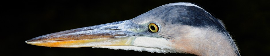
You can see from this one why I call it snag lake.  The picture was taken on a hot afternoon but in the morning, those snags are perches for Eagles, Osprey, and all the other fishing birds of the area.  Storks, egrets and herons are plentiful and I have seen several bittern in the reeds.


A little further along, you will find a final pond just a few hundred yards from Route 31 which is also good for egrets and herons.  The end of this section though is just across from the main entrance to Babcock Ranch.

While this area is normally closed to vehicular traffic, it is well worth the drive when open.  Even when closed, you can park and climb the gate and walk to Snag Lake.  Just be sure not to block the gate.  While it is kept locked, it does provide access to the eastern parts of the WMA and can see heavy use by FPL trucks getting to Powerline Grade and the heavy equipment used to to maintain the grades in the area.

Posted in Park | Tagged , | Leave a comment

Another visit to Venice Rookery

I needed to go up to Sarasota today.  My picture of a Ramburs Forktail took an honorable mention in a juried show of the Sarasota Camera Club.  I stopped by the Venice rookery on the way to see what the activity was like.  The great Egrets have arrived and are beginning to  nest on the island and the Anhinga are busy.  There was one Great Blue Heron nest with a couple of chicks but no good angle to get a decent shot.   Both of these birds have their mating colors on display around the eyes.

The new oak trees have been planted but it will be a long time before they create any effective shade.  One thing the clearing did was to give angles for good lighting  all day long for flight shots.  Several of the Great Blue Herons were definitely sitting on eggs in lower nests at the front of the island so there should be some good opportunities for baby pictures soon.

Posted in Bird, Park, Venice Rookery | Tagged , , , | Leave a comment